Catastrophic Loss of Peat, Fire, and Acid Sulphate Soils in SW Australia
May 10th, 2018 • QEDmedia • Uncategorised
This cut and paste hatchet job is in response to a chance meeting in Walpole.
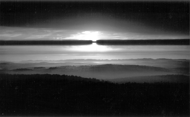
View West from Mt Frankland, 7th December 1988
Sun occluded by layer of smoke from CALM, burn
(This image needs to be seen as a real silver gelatine print, as its subtle and crucial highlight and shadow gradation are lost in the process of digital scanning for showing on the WWW)
Preface
This post deals with wetlands and losses of peat, detritivores and edaphic processes due to innapropriate fire use in D'Entrecasteaux, Shannon and Walpole Wilderness Area National Parks, Western Australia.
For the landscape and environmental documentation portfolios this means gaining some understanding the ecology, geology, hydrology and the other 'ologies of the landscape I am working in. When driving to Windy Harbour I used to see strange pedestals with grassy tops. These intrigued me, but it was not until I atternded the Western Australian Dep't of Conservation and Land Management, CALM, Fire Symposium in 2002 that I became engaged
This engagemnent happened in the single part of this symposium that grabbed my total attention. "Fire and organic substrates: soil structure, water quality and biodiversity in far south-west Western Australia", a paper by Pierre Horwitz, Simon Judd and Bea Sommer. There in front of me druing the presentation were pictures of peat pedestals. Suddenly they they had a causal factor; a name, peat pedestals; and a plant name, Leptocarpus scariosus. And I had a new story.
I accept the notion, first heard from Richardo Gonzalez, who was Manual Alvarez Bravo's minder in about 1979 when I met them in Lindon, that it is crucial for a photographer to run personal and documentary projects simultaneously to keep a broad view within one's work
Peat Loss
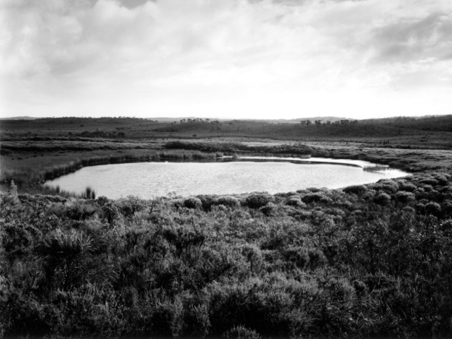
Small permanent lake to west of Windy Harbour Road. June 2003
This lake is surrounded by warren river cedar root bases and the bed of the lake contains “peat coke”. At a public meeting in Northcliffe on 13th October 2005 CALM admitted that lakes like this were originally peat filled depressions with a cover of warren river cedar Taxandria juniperina, since destroyed by fire.
The D'Entrecasteaux National Park, in southwest Western Australia, is a hotspot within one of the 25 most bio-diverse hotspots on earth. Within this is the Doggerup Plain, an area of open heath, dotted with bare granite outcrops (monadnocks) and small circular lakes. The monadnocks are often surrounded by stands of karri and marri. From a distance they look like tree islands.
It sounds ancient and untouched – it isn't. I believe that until its relatively recent use by the Ipsen family and other Manjimup graziers the landscape was quite different. I understand the open heath formerly as a low canopy forest of peppermint, Warren River cedar Taxandria juniperina, banksia and Christmas trees Nuytsia floribunda in a high organic content soil. The granite monadnocks were covered in moss and plants, The small circular lakes were peat filled depressions containing stands of warren river cedar. Warren River Cedar is an extremely fire sensitive species and even a minor burn near the base is fatal (Kippert L, Northcliffe, p.c. 2005). The cedar canopy and the peat, up to 0.8mtr higher than present levels, maintained a wetter local environment than now exists. This wetter environment protected the peat from desiccation and fire.
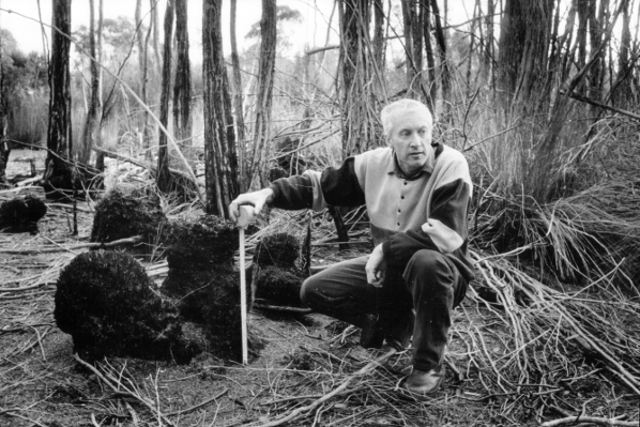
Jeff Bennett, Fire Control Officer, CALM Donnelly District, with peat pedestals,
D'Entrecasteaux National Park during a field trip with Northcliffe Environment Centre, June 2002
Peat pedestals indicate the original peat level. It is understood they are formed by the peat around the roots of various plants being kept moist (cooler) during some peat burns. Peat pedestals are usually lost during the next burn. (Horwitz et al 1999)
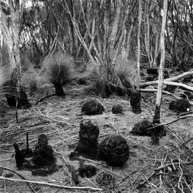
Peat pedestals in D'Entrecasteaux National Park June 2002
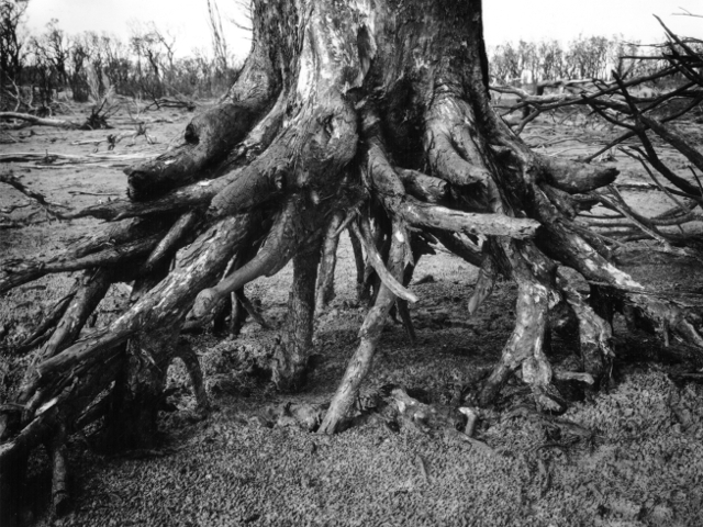
Lake Surprise, Northern Side, Exposed Root Base following 2003 fire
Loss of organic soil is clearly indicated. Lake Surprise is in the Walpole Wilderness area. This photograph and the one below, indicate the kind of peat loss experienced in D'Entrecastaux.
My photographic record of Lake Surprise 2003 is scant. While I was silently sitting and absorbing the place, or being absorbed by it, the idiot I went with was running around the ash bed hunting for photographs. So when I felt accepted and started to work the 'till-then pristine ash-bed had size ten boot prints through it. I have never forgiven him.
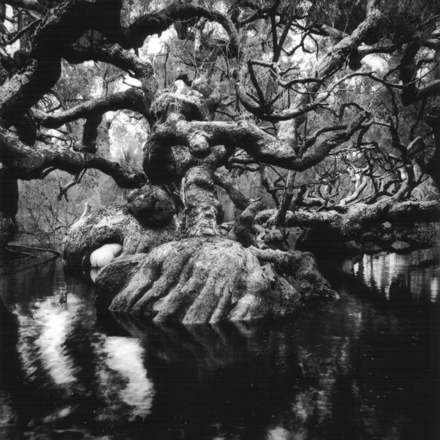
Goblin Swamp, D'Entrecasteaux National Park 1997
Showing fire exposed Melaleuca root bases from peat loss, and a bum.
Cattle Grazing, Fire and Loss of Peat
The damage started with the use of the area by Manjimup graziers, who lit fires behind them as they left after the summer feeding.
Autumn burning in peat lands has been continued by the Western Australian Department of Environment and Conservation DEC, formerly CALM. Burning in the autumn allows the peat to ignite and smoulder, even after rain.
Evidence for this view of the damage to D'Etrecasteaux comes from the peat pedestals, the remains of former warren river cedar root bases and the juvenilisation of remaining warren river cedar. Peat pedestals indicate the original peat level. It is understood they are formed by the peat around the roots of various plants being kept moist during some peat burns. The are usually lost during the next burn Horwitz et al 1999. It is claimed by local groups that the autumn burns follow aboriginal practice. If, after thousands of years, aboriginal burning practices in this area caused peat to burn there would be no remaining evidence of peat pedestals or recent warren river cedar root bases
The Doggerup peat acted as a sponge, slowing the flow of water through the land Horwitz et al 1999. This former slow drainage is indicated in a documented conversation between Bill Ipsen and Charlie House, where the drying of formerly summer long fresh water springs at the coast is recorded Ipsen W self published 2000 p58. The obvious correlation between the loss of peat swamps and low canopy forest, with loss of fresh water at the coast, was never made by Manjimup graziers.
Peat loss is irreversible given the current mix of plants and the drying climate. As already stated, CALM/DBCA continues to use fire inappropriately in the peat lands. Fire must now be excluded from all peat areas. It has been my observation at Lake Surprise that peat will burn even when wet. The mechanism for this wet burning was being researched McCormick, C. pc. 2005. Protection of peat will require fire landscape/burn programs to be considered in much smaller units than has been used so far. In future it is important to assess the burn area at the scale of peat swamp by peat swamp. Also crucial is the measurement of the organic content of soils between peat swamps to assess the danger of widespread organic soil loss.
Abstract from submission to Western Australian Government
Fire Use in General
Karara State Forest October 2004
Burnt tiny Diverse Ecotype Zone including Melaleuca sp. adjacent to Durham Road,
The subject of general CALM, Western Australian Dep't of Conservation and Land Management, controlled burning is far too complex, under-researched and misunderstood to be dealt with in this photo-website. I will therefore limit this section to the following observations
Firstly, from the papers delivered to the Fire Symposium in Perth in April 2002, it is obvious that a vast amount of independent research is still needed. During the symposium I received the distinct impression that CALM/DBCA research is predicated on preserving the "cash for fire" status quo.
One of the main problems appears to be the continuing change in the forest vegetative assemblage, which some research results indicate to be a direct result of current broad scale burning practices. Local knowledge records that prior to clearfelling and broad scale use of fire in the Southern Forest karri areas maintained too wet an environment to burn, the edaphic natural fire defence which is now lost.
Current burn practices also fail to avoid the burning of tiny diverse ecotype zones, DEZs, see Burnt Melaleuca Karara State Forest above.
I know that addressing these points would require greatly increased manpower during controlled burns. However, I believe that forest, which must be seen as a large system consisting of many small interdependent ecosystems, is worth the effort and cost to protect
Appendices
Acid Sulphate Soils
21st June 2006
Recent local news reports state there is concern over acid sulphate soils affecting developments in the south west of Western Australia. Acid sulphate soils are created by damage to the soil profile. Wherever wetlands have formed over iron bearing rock, which is much of the south west of Western Australia, the partial decomposition of fallen organic material created ferrous sulphide, iron pyrites, in an anaerobic environment. This occurred about 5000 years ago. When this anaerobic layer is removed by fire or development the ferrous sulphide combines with oxygen in the presence of water and through fairly simple reactions forms sulphuric acid. Following CALM fire I have witnessed the measurement of acidity readings of pH3
As with selling "developments" plagued with mosquitoes in this area (13th March posting below) it demonstrates public dis-information by state and local government and developers at an almost criminal level. Now these developers are screaming to the WA Government for more land to sell to the uninformed
Geography Bay - ART-GEO Wetlands Exhibition Project
13 March 2006
(Green-Washing Wetland Sub-Urbanisation & Larvicide Use)
ART-GEO WETLANDS EXHIBITION was an exhibtion conceived by Helena Sahm at the ArtGeo Gallery Busselton for exhibition in August 2006. The artists involved in this poject were being asked to show the sub-urbanised Busselton area wetlands in a positive light and show their good aspects
There are no good aspects – the wetlands around Busselton are in terminal decline - a body of stagnant water is not the same as a thriving biodiverse wetland. There is a constant increase in sub-urbanisation and associated wetland damage. Nicole Lincoln from DEC/GeoCatch (Geographie Water Catchment) stated that the developers drained the water into features surrounded by the right vegetation - but did not make the observation that narrow and deep is not as good as broad and shallow.
Compounding the damage, the owners of the new houses now want the Busselton Shire to undertake mosquito eradication by means of larvicide. What the people who are buying into these sub-urbaniations don't give a damn about is that their poisons will not differentiate between insect larvae of mosquitoes and other species, or other arthropods. These tiny crustacia are crucial in the shredding and movement of organic material. To buy into coastal wetland development then complain of Ross River Virus threat shows stupidy beyond the dreams of the developers. These lands have always been home for mosquitoes and it is my understanding that with the decay of the wetland ecosystems the surface air breathing mosquito larvae are given a breeding advantage over more vulnerable gill breathing arthropods
Peat + Fire = Localised Extinctions
10th March 2006
Well publicised is the worldwide panic over loss of peat-swamps in Indonesia, Malaysia, Borneo, Alaska and the Siberian Tundra. Given these internationally recognized facts, we have a situation in WA that requires the precautionary principle to be applied to our relictual peat-lands with great rigour
With this knowledge and in the face of clear evidence of D'Entrecasteaux peat losses from summer/autumn burns, which also destroys many rare aestivating fish, CALM/DEC Frankland District, Walpole, went ahead with a "prescribed burn" in the Woolbales area of the D'Entrecasteaux National Park. Predictably the fire escaped, and travelled to Broke Inlet. It was kept out of the settlement of Camfield, but destroyed almost all the peat around the northern edge of Broke. DEC's own estimates for this feral fire (I don't accept these escapes as being wild fires) are 2,000ah and 10,000ha. DEC described the weather as mild, but local observers tell me the temperature was 32°C with a south easterly wind. DEC Frankland District was also guilty of the 2003 Lake Surprise and 2004 Karara peat losses illustrated above.
The recent fire, like the fires in 2003 and 2004, appear to disregard obvious safeguards. There was a danger that a fire lit at this time of year in these conditions could have spread to the Brooke's Inlet settlement of Camfield. DEC's excuse for the fire was to "protect and regenerate certain plant species Banksia verticillata andReedia spathia. Reedia isparticularly fire sensitive and almost extinct. DEC Fire expert Ric Sneeuwjagt was "unconcerned".
All Over: Too Late: Finished
13th October 2008
The environment was the ultimate concern for all humanity. The wanton destruction of the Swan Coastal Plain peat and the SW Karri and Jarrah Forest were only two aspects of the creeping environmental apocalypse. All those who drank Chardonnay and talked about the environment were not conservationists. It was our duty to act in whatever way we could, we were not powerless
However, it is now all too late. Due to rising world temperature the Siberian and Alaskan permafrost above thoser huge peatlands is melting and the peat can become aerobic . . .
Whoopee, all life is going to die slowly and horribly - Thank you the world timber industry, graziers and Volvo drivers. Oh, Volvo drivers included me
References
"Catastrophic Loss of Organic Carbon from a Management Fire in a a Peatland in Soutwestern Australia" Pierre Horwitz, Michael Pemberton and Darren Ryder. Wetlands for the Future pp487-500. Edited by A.J. McComb and J.A. Davis. Gleneagles Publishing Adelaide, 1999.
Follow That Bell" Bill Ipsen self published Manjimup, Western Australia December 2000. Which I read as his Mea culpa.
"Fire and Organic Substrates: Soil Structure, Water Quality and Biodiversity in Far South-West Western Australia". Pierre Horwitz, Simon Judd and Bea Sommer. Fire In Ecosystems of South-West Western Australia: Impacts and Management, pp381-393. Edited by Ian Abbott and Neil Burrows. Backhuys Publishers, Leiden, Netherlands, 2003. (Sadly, any papers in the 2002 symposium that were critical of CALM were heavily editied by Abbott and Burrows of CALM to remove any critisism of CALM)
Acknowledgements
Pierre Horwitz PhD, for his 1999 paper, which opened our eyes to what we were witnessing in D'Entrecasteaux National Park and Lake Surprise
Caroline McCormick, for her observations on the pyrolysis of peat.
Jeff Bennett, CALM, for looking and listening during field trips in 2002.
David Hyde, photographer, for taking me to damaged sites north and east of my usual working areas.
Copyright John Austin 2009 Quinninup Western Australia
← Return to Blog

 RSS Feed